


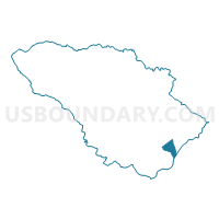
Howard Precinct 06-030, Howard County, Maryland
About
Outline

Summary
| Unique Area Identifier | 592529 |
| Name | Howard Precinct 06-030 |
| County | Howard County |
| State | Maryland |
| Area (square miles) | 2.06 |
| Land Area (square miles) | 2.06 |
| Water Area (square miles) | 0.01 |
| % of Land Area | 99.75 |
| % of Water Area | 0.25 |
| Latitude of the Internal Point | 39.16285930 |
| Longtitude of the Internal Point | -76.79158320 |
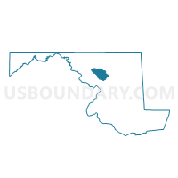
Maps

Graphs
Select a template below for downloading or customizing gragh for Howard Precinct 06-030, Howard County, Maryland


Neighbors
Neighoring Voting District (by Name) Neighboring Voting District on the Map
- Anne Arundel Precinct 01-022, Anne Arundel County, MD
- Anne Arundel Precinct 01-023, Anne Arundel County, MD
- Howard Precinct 01-006, Howard County, MD
- Howard Precinct 01-015, Howard County, MD
- Howard Precinct 06-007, Howard County, MD
- Howard Precinct 06-019, Howard County, MD
- Howard Precinct 06-029, Howard County, MD
Top 10 Neighboring County Subdivision (by Population) Neighboring County Subdivision on the Map
- District 6, Savage, Howard County, MD (90,720)
- District 1, Anne Arundel County, MD (72,934)
- District 1, Elkridge, Howard County, MD (40,142)
Top 10 Neighboring Place (by Population) Neighboring Place on the Map
- Columbia CDP, MD (99,615)
- Ilchester CDP, MD (23,476)
- Elkridge CDP, MD (15,593)
- Jessup CDP, MD (7,137)
- Savage CDP, MD (7,054)
Top 10 Neighboring Unified School District (by Population) Neighboring Unified School District on the Map
Top 10 Neighboring State Legislative District Lower Chamber (by Population) Neighboring State Legislative District Lower Chamber on the Map
- State Legislative District 13, MD (131,784)
- State Legislative District 32, MD (131,384)
- State Legislative District 21, MD (130,048)
Top 10 Neighboring State Legislative District Upper Chamber (by Population) Neighboring State Legislative District Upper Chamber on the Map
- State Senate District 13, MD (131,784)
- State Senate District 32, MD (131,384)
- State Senate District 21, MD (130,048)
Top 10 Neighboring 111th Congressional District (by Population) Neighboring 111th Congressional District on the Map
Top 10 Neighboring Census Tract (by Population) Neighboring Census Tract on the Map
- Census Tract 7401.02, Anne Arundel County, MD (6,497)
- Census Tract 6069.01, Howard County, MD (5,549)
- Census Tract 6067.06, Howard County, MD (4,798)
- Census Tract 7404, Anne Arundel County, MD (4,716)
- Census Tract 6011.07, Howard County, MD (4,214)
- Census Tract 6012.03, Howard County, MD (3,893)
- Census Tract 6067.07, Howard County, MD (3,755)